Today I am writing a post about the Open Data movement (theory by Wikipedia).
Sure, it is a new tendance in the Geomatics landscape. It is possible to see some actions about this in different countries and not only in "occidental" countries.
One of the first popular action is Open Street Map and the activity its is growing up in all the countries in Europe.
It is easy to see the evolution in countries like FYROM, Belarus,Albania and Kosova with the help of the Geofabrik.de applications.
If I remember, it was in a previous post in September 2010.
In Greece, the Opendata.gov.gr is an example of this action for a free and open data (don't forget that we speak about geodata ;-)
Now, this post treats about the Open Data movement but not just about data. I want to present the movement in public authorities like municipalities.
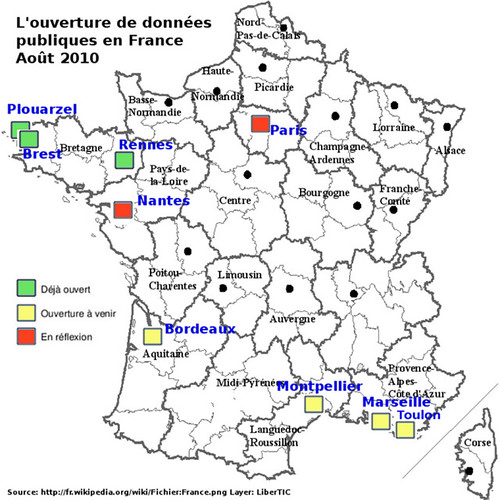
For this I present an example from France with some maps that they illustrate the situation. This movement in France is " trendy ". The last year, we observe different municipalities or public authories that they "open" their geodata to the people.
One map is this http://www.flickr.com/photos/46243777@N07/5422451858/
It present the French cities that they are implicated in a demarch to open the public data. So, we observe two cities : Rennes and Paris
You can see others authorities like some french departments and regions: Aquitaine, Isere, PACA...
OSOR.eu published an article about Rennes and its politic with many links but in french.
If we compare with an other map from the libertic blog in August 2010, we observe that others cities and municipalities from Brittany (France) have opened their data: Brest and Plouarzel.
Sources are here:
This OpenData movement is fresh and it is possible to discover it in blog and french geomatics website.
If you love Paris...you can discover Paris by Open GeoData. The guys of 3liz (Famous french "Open" Company in geomatics) have developped a geoweb applications client: http://demo.3liz.fr/opendataparis
The database in background seems very big! Trees, pedestrian tracks, buildings, natural objects...
This demarch offers to the public to use and re-use the geodata in order to purpose some open applications for best services to the citizens. A demarch more and more trendy in some countries.
To be continued...
Δεν υπάρχουν σχόλια:
Δημοσίευση σχολίου
Αφήστε το σχόλιό σας εδώ...