Ανάλαβα μια ανακοίωνση από το ΕΛ.ΚΕ.ΘΕ... Πιστεύω να ενδιαφέρει πολλά άτομα. Την βάζω παρακάτω.
Το Ελληνικό Κέντρο Θαλασσίων Ερευνών (ΕΛ.ΚΕ.Θ.Ε) στα πλαίσια του
Ευρωπαϊκού Ερευνητικού προγράμματος HUMBOLDT, διοργανώνει Ημερίδα
(Workshop) στις 28 Μαρτίου 20011 με τίτλο «Προγραμμα HUMBLODT, μια
προσπάθεια εναρμόνισης γεωχωρικών δεδομένων».
Σκοπός τηs ημερίδας είναι η γενική παρουσίαση των στόχων αλλά και των
αποτελεσμάτων και των εργαλείων λογισμικού που
σημιουργήθηκαν από το πρόγραμμα.
Επίσης Παρουσιάζεται η σχέση του με διεθνή πρότυπα και η συμβολή του
στην υλοποίηση της κοινοτικής οδηγίας INSPIRE.
Περισσότερες πρηροφορίες σχεχτικά με το πρόγραμμα μπορείτε να βρείτε εδώ :
http://www.esdi-humboldt.eu
Η Ημερίδα θα πραγματοποιηθεί στις εγκαταστάσεις του ΕΛ.ΚΕ.Θ.Ε. 46,7 χιλ.
Λεωφ. Αθηνών Σουνίου, Ανάβυσσος.
Παρακαλούμε του ενδιαφερόμενους να ακολουθήσουν τον παρακάτω σύνδεσμο για
εγγραφή στην Ημερίδα.
http://mapserver.ath.hcmr.gr/workshop/form/form.php
ΓΙΑ ΤΟ προγραμμα της ημερίδας ακολουθήστε το παρακάτω link
ftp://ftp.ath.hcmr.gr/noc/agendatiming.doc
Υπλογιστικό Κέντρο ΕΛ.ΚΕ.Θ.Ε.
Τετάρτη 23 Μαρτίου 2011
Δευτέρα 21 Μαρτίου 2011
...η Ιαπωνία και ο σεισμός
Δεν έχω λόγια για αυτά που έγιναν εδώ και 10 μέρες στην Ιαπωνία, αλλά αυτή η καταστροφή δημιουργεί μια μεγάλη κίνηση στο τομέα των χωρικών δεδομένων από δορυφόρους.
Αυτή η κίνηση είναι σαν αυτή που έγινε στην Αϊτή μετά από το σεισμό.
Έτσι έχουμε πάρα πολλές πληροφορίες για τα αποτελέσματα της καταστροφής με χάρτες υψηλής ποιότητας.
Το άρθρο αυτό σας παρουσιάζει μερικές εφαρμογές για την περιοχή που ήρθε αντιμέτωπη με την καταστροφή.
Χάρτες από UN-SPIDER
http://www.un-spider.org/japan-pacific
Χάρτες από το Washington Post:
http://www.washingtonpost.com/wp-srv/special/world/japan-earthquake.html
Ιαπωνικές εφαρμογές/webgis από το Ushuahidi (Crisis Applications)
http://blog.ushahidi.com/index.php/2011/03/16/crisis-mapping-japans-earthquake-and-how-you-can-help/
και
http://www.sinsai.info/ushahidi/
Μια εφαρμογή πάνω σε Google Maps για να δούμε τα στοιχεία...έτσι απλά.
http://www.google.com/crisisresponse/japanquake2011.html#map
Τέλος η εφαρμογή με δυναμικά στοιχεία για κάθε σεισμό που έγινε μετά από το Μεγάλο Σεισμό στις 11 Μαρτίου 2011.
Η εφαρμογή αυτή είναι πολύ ενδιαφέρουσα με τη ζωντανή μετάδοση (εμψύχωση) των σεισμών http://www.japanquakemap.com/
Υπήρχε η ίδια εφαρμογή για τη Νέα Ζηλανδία (http://www.christchurchquakemap.co.nz/ ). Ο δημιουργός είναι ο Paul Nicolls από το Πανεπιστήμιο της Canterbury.
Και πολλά άλλα που υπάρχουν σε διαφορετικά τμήματα πανεπιστημίου που συνεργάζονται με τις υπηρεσίες πολιτικής προστασίας...
Παρασκευή 11 Μαρτίου 2011
Bug for upgrade on Wordpress
It is not in direct relation with geomatics but it is a subject for the data diffusion on internet.
To make a GeoWeb application is a first step but it could be better to insert it in a frameword like a ''iframe'' (Google maps or OSM ).
This post treats about one example of CMS that I use every day for my work: Wordpress CMS.
And when you design a website or an application with Wordpress and after time you upgrade this version of Wordpress, it is possible to have any bugs and problem.

It was my case. This problem is about the upgrade of the WP version 3.0.4 to 3.1
As consequence, you have a problem with your sidebar widget and the next beautiful message:
It is a common problem these last days with the update of WP.
It was necessary to lose 1 day for this!
This update has a consequence for many ready themes.
So, for this problem, you need to modify your db table : prefix_options (generally wp_options and to delete the widget_sidebar row.
This option with the sidebar is out now with the 3.1
Post http://wordpress.org/support/topic/changing-prefix-wp-causes-warning-array_key_exists?replies=12
And now go to implement your Geo Application on-line in your favourite cms...
To make a GeoWeb application is a first step but it could be better to insert it in a frameword like a ''iframe'' (Google maps or OSM ).
This post treats about one example of CMS that I use every day for my work: Wordpress CMS.
And when you design a website or an application with Wordpress and after time you upgrade this version of Wordpress, it is possible to have any bugs and problem.
It was my case. This problem is about the upgrade of the WP version 3.0.4 to 3.1
As consequence, you have a problem with your sidebar widget and the next beautiful message:
Warning: array_key_exists() [function.array-key-exists]: The second argument should be either an array or an object in /wp-includes/widgets.php on line 858 It is a common problem these last days with the update of WP.
It was necessary to lose 1 day for this!
This update has a consequence for many ready themes.
So, for this problem, you need to modify your db table : prefix_options (generally wp_options and to delete the widget_sidebar row.
This option with the sidebar is out now with the 3.1
Post http://wordpress.org/support/topic/changing-prefix-wp-causes-warning-array_key_exists?replies=12
And now go to implement your Geo Application on-line in your favourite cms...
Πέμπτη 10 Μαρτίου 2011
The Open Data is trendy
Today I am writing a post about the Open Data movement (theory by Wikipedia).
Sure, it is a new tendance in the Geomatics landscape. It is possible to see some actions about this in different countries and not only in "occidental" countries.
One of the first popular action is Open Street Map and the activity its is growing up in all the countries in Europe.
It is easy to see the evolution in countries like FYROM, Belarus,Albania and Kosova with the help of the Geofabrik.de applications.
If I remember, it was in a previous post in September 2010.
In Greece, the Opendata.gov.gr is an example of this action for a free and open data (don't forget that we speak about geodata ;-)
Now, this post treats about the Open Data movement but not just about data. I want to present the movement in public authorities like municipalities.
For this I present an example from France with some maps that they illustrate the situation. This movement in France is " trendy ". The last year, we observe different municipalities or public authories that they "open" their geodata to the people.
One map is this http://www.flickr.com/photos/46243777@N07/5422451858/
It present the French cities that they are implicated in a demarch to open the public data. So, we observe two cities : Rennes and Paris
You can see others authorities like some french departments and regions: Aquitaine, Isere, PACA...
OSOR.eu published an article about Rennes and its politic with many links but in french.
If we compare with an other map from the libertic blog in August 2010, we observe that others cities and municipalities from Brittany (France) have opened their data: Brest and Plouarzel.
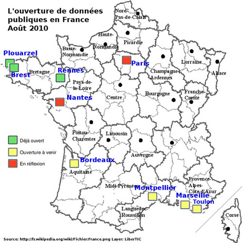
Sources are here:
This OpenData movement is fresh and it is possible to discover it in blog and french geomatics website.
If you love Paris...you can discover Paris by Open GeoData. The guys of 3liz (Famous french "Open" Company in geomatics) have developped a geoweb applications client: http://demo.3liz.fr/opendataparis
The database in background seems very big! Trees, pedestrian tracks, buildings, natural objects...
This demarch offers to the public to use and re-use the geodata in order to purpose some open applications for best services to the citizens. A demarch more and more trendy in some countries.
To be continued...
Εγγραφή σε:
Αναρτήσεις (Atom)